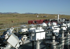
NREL Solar Radiation Research LaboratoryBaseline Measurement System |
|
Latitude: 39.742o North Longitude: 105.18o West Elevation: 1828.8 meters AMSL |
Data sets currently available on SRRL BMS web site
- "Live" graphical display, updated every 60 seconds.
- "Live" PDA display, updated every 60 seconds.
- "Live" data and plots, updated every 60 seconds.
- Daily plots and raw data files, including wind roses, are available from July 15, 1981 to yesterday.
- Solar calendars, are available from July 1981 to the present month.
- Wind roses for all historical wind data, this includes:
- Monthly roses for April 1988 to last month.
- Seasonal roses for Summer 1988 to last season.
- Yearly roses for 1989 to last year.
- Historical Monthly data are available, this includes:
- Quality assessed data for July 1981 to last month.
- Monthly reports (ASCII) for July 1981 to last month.
- Cylinder plots for January 1997 to last month.
- QCFit plots for January 1997 to last month.
- Full flag summaries for July 1981 to last month.
- Flag summary tables for July 1981 to last month.
- Historical reports and plots are available, this includes:
- Monthly reports (PDF) for July 1981 to last month.
- Monthly plots for July 1981 to last month.
- Yearly data and plots can be generated using statistics extracted from monthly reports.
- An EKO All Sky Imager (ASI-16) is capturing all sky images and computing cloud cover since September 26, 2017, this includes:
- A Sky Image Snapshot of the current sky-conditions, updated every 60 seconds.
- Total sky images and "cloud analyzed" images (with cloud cover values), every 10 minutes.
- Percentage of thick and thin cloud cover, every 10 minutes.
- Percentage of thick and thin cloud cover, since September 26, 2017.
- A Yankee Total Sky Imager (TSI-880) is capturing all sky images and computing cloud cover since July 14, 2004, this includes:
- Total sky images and "cloud analyzed" images (with cloud cover values), every 10 minutes.
- Percentage of opaque and total cloud cover included with the BMS "live" and daily time series data stream, every 60 seconds.
- An NREL-built All-Sky (180o fish eye lens) Web Cam was available, this includes:
- The SkyCam Image Gallery contains historical snapshots every hour (during the day), are available from September 3, 1999 to May 8, 2017.
- The Daily SkyCam Animations will animate all the hourly historical snapshots.
- Several Spectroradiometers have been measuring spectral data, since January 24, 2001, updated every 60 seconds.
- GPS-based Precipitable Water Vapor (PWV) measurements are available since June 13, 2012, updated every 60 minutes.
- Aerosol Optical Depth (AOD) measurements are available since June 11, 2013, updated every 24 hours.
- A Spectrafy SolarSIM-D2+ is providing direct normal spectral models since September 1, 2016, updated every 60 seconds.
- A Spectrafy SolarSIM-G is providing global horizontal spectral models since April 30, 2021, updated every 60 seconds.
- An EKO MS-300LR Sky Scanner has mapped luminance and irradiance, from June 14, 2000 to October 28, 2002, every 15 minutes.
- Compute the solar position and/or intensity from time and place using MIDC's Solar Position Calculators.
- Develop a renewable resource climatology for NREL in Golden, Colorado.
- Provide outdoor facilities for radiometer calibration and characterizations.
- Conduct measurement-related research and development in support of the renewable energy conversion technologies.
- Provide excellent solar access at the South Table Mountain location.
- Collect continuous research-quality measurements of solar radiation and other surface meteorological parameters.
- Develop improved methods for outdoor radiometer calibration and characterization traceable to international standards.
- Coordinate the varied outdoor research data acquisition projects.
- Provide NREL research programs with access to an outdoor laboratory with optimum instrument mounting platforms, automatic data acquisition systems, and regular operation and maintenance procedures.
- Continued operation of the Baseline Measurement System (1-minute data from over 80 instruments, including pyranometers, pyrheliometers, pyrgeometers, anemometers and other meteorological sensors). Instrument pictures and documentation is available.
- Development and evaluation of radiation measurement platforms for resource monitoring network applications.
- Transfer radiometer calibrations traceable to the World Radiometric Reference scale of measurement using absolute cavity radiometer intercomparisons.
- Support the seasonal Broadband Outdoor Radiometer Calibration (BORCAL) function of NREL's Metrology Laboratory.
- Support the outdoor characterization of photovoltaic devices.
- Implement architectural design for improved Mesa Top facilities to meet increasing needs of research and development.
- Visit the Solar Radiation Research Home Page for more information.
- Hourly solar radiation and surface meteorological data base for NREL.
- Contribute 1-minute data to World Meteorological Organization's Baseline Surface Radiation Network.
- Annual calibrations of approximately 200 pyranometers and pyrheliometers.
- Research and development of improved radiometer calibration techniques for DOE's Atmospheric Radiation Measurement (ARM) program.
- Development of solar radiation resource measurement systems for international applications.
- Characterization of low-cost radiation measurement systems for utility applications.
- SRRL Rotating Shadowband Pyranometer/Radiometers
- SRRL GPS-Based Precipitable Water Vapor (PWV)
- SRRL Aerosol Optical Depth (AOD)
- SRRL Spectrafy Direct Normal SolarSIM-D2+
- SRRL Spectrafy Global Horizontal SolarSIM-G
- SRRL Kipp & Zonen RaZON+
- SRRL PV Resource Study
- SRRL Baseline Surface Radiation Network (BSRN) proto-type station
- SRRL Atmospheric Optical Calibration System (AOCS)
- SRRL Ancillary Data
Andreas, A.; Stoffel, T.; (1981). NREL Solar Radiation Research Laboratory (SRRL): Baseline
Measurement System (BMS); Golden, Colorado (Data); NREL Report No. DA-5500-56488.
http://dx.doi.org/10.5439/1052221
For more information about SRRL BMS contact: Afshin Andreas
